
Do you have trouble walking in your neighbourhood of Kelowna? Do you, like I do, eagerly await the development of more walking-friendly infrastructure?
If so, you will doubtless be fascinated by the details revealed in the new Existing and Future Conditions Technical Report produced as part of the planning for next year’s Transportation Management Plan (TMP). The TMP will guide the city’s development with regards to all modes of transportation for the next twenty years, so the report was made to help all of us understand what it might be like to move around the city in the near future.
What is the report about?
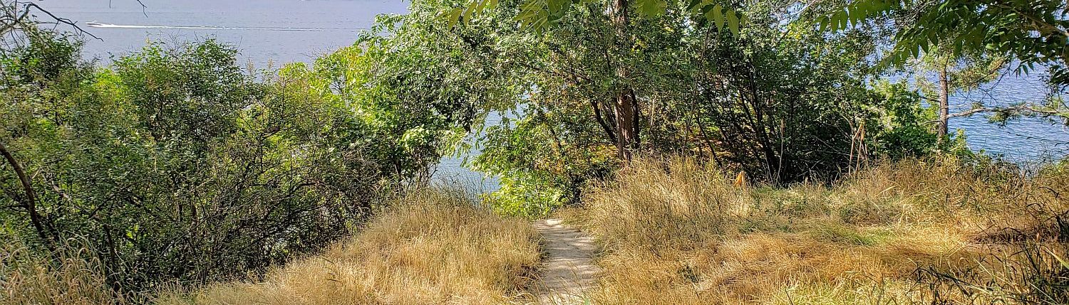
On this blog, I like to tell you about my adventures discovering parks and other fascinating features of the local landscape, but not all walking is spare-time recreation. Unlike the Linear Parks Master Plan, the Transportation Management Plan is more concerned with the most common day-to-day movements. For the most part that means commuting and shopping. Of course, the report has plenty to say about biking, taking transit, and driving (especially about congestion). In this post, however, I am focusing on what it says about walking.
Read on to find out about the state of walking in Kelowna today.
What is the State of Walking in Kelowna Today?
Not only does the Technical Report have something to say about walking, but walking is first on the list of transportation modes to be discussed. As the most natural form of transportation, walking doesn’t require special vehicles or scheduled trips but it can still benefit from special attention.
Kelowna has grown up as a very car-dependent city, but that has not stopped people from walking. According to surveys, eight percent of trips in Kelowna are made by walking. The major factor in people’s decision to walk is trip length. Very few people in Kelowna choose to walk regularly for trips that are two kilometres or more.
Here are the walking mode shares for short trips.
- 60% of trips shorter than 500 metres long are made by walking
- 36% of trips 500 metres to one kilometre long are made by walking
- 19% of trips one to 1.5 kilometres long are made by walking
The percentage goes up in a dense urban environment. Downtown, seventeen percent of trips are made by walking.
What Does the City Want to Do?
Given the continued population growth that is expected for the Kelowna region, and the increase in traffic congestion that would result if all of those new residents drove cars everywhere, the city would like it if people chose to walk (or bike, or take transit) instead of using their cars.
Since most people don’t want to walk more than a kilometre or so, trips of that length are the ones the city wants to focus on.
Currently, eleven percent of trips are shorter than one kilometre in length, and another thirteen percent are between one and two kilometres. That means twenty-six percent of trips can reasonably be called ‘walking distance’ given the reported proclivities of survey respondents.
Therefore, the city would like to increase the share of walking trips from eight percent of all trips to twenty-six percent of all trips.
How Does the City Intend to Increase Walking?
The Report discusses several strategies for making walking a more desirable choice. Let’s look at them one at a time.
1. Creating a Safe Walking Environment

People are more likely to walk when they feel safe. Even though pedestrian accidents make up a very small number of collisions each year, when a pedestrian is involved in a collision, they are far more likely to be injured.
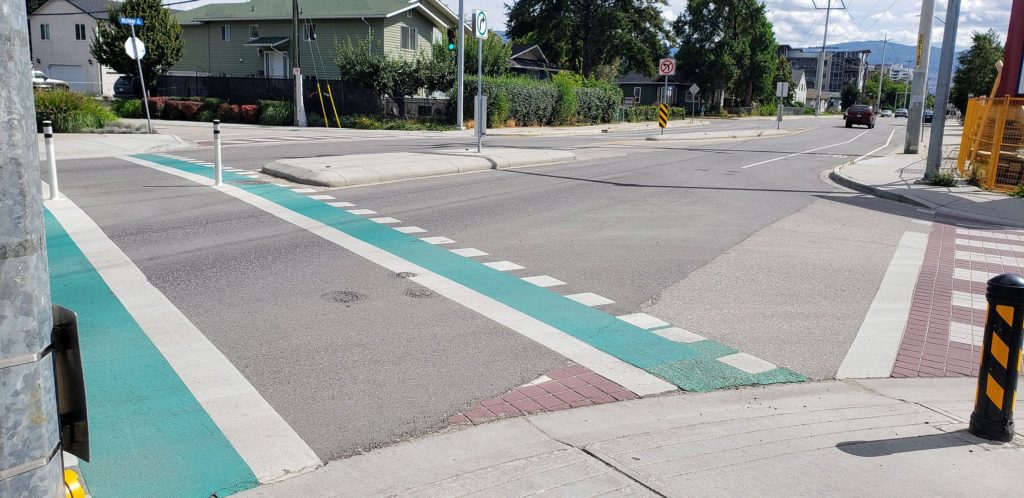
One of the best ways to help walkers feel safer is to build sidewalks. Though there are some neighbourhoods, like Downtown, where nearly all streets have sidewalks on both sides, there are others, like Rutland, where only major streets have sidewalks, and still others, like South Kelowna, where there are almost no sidewalks.
Another way to help walkers feel safe is to have marked crosswalks. Though it is legal for pedestrian traffic to cross at almost every intersection, people feel safer if a crosswalk is marked. Beyond the simple white lines, the feeling of safety can be increased with flashing lights to increase visibility and corner bulges to shorten the crossing distance.
2. Creating an Attractive Walking Environment
People enjoy walking more when their route is designed at a human scale with pedestrians in mind. Many of the landscapes in Kelowna were developed with motor vehicles in mind and with pedestrians as an after-thought, if they were considered at all. One can walk there, sure, but it is definitely less pleasant than wandering down a pedestrian-oriented path like the Downtown Artwalk.
Walkers appreciate wide sidewalks and pleasant landscaping. They also appreciate street furniture, such as benches and garbage cans. Walkers definitely appreciate public washrooms, but in Kelowna I have only seen those in parks, so far.
3. Creating a Convenient and Connected Walking Network
Since trip length is the number one factor in people’s decision whether to walk, it makes sense that walkers will take advantage of any short-cuts and connections that will make their trip quicker. Whether it’s slipping in between buildings or cutting across a field, walkers will try to take the most direct route.
In car-oriented landscapes, those connections can be very limited. In order to encourage people to walk, therefore, the city wants to provide crossings in the middle of long blocks, and in some cases to break up long blocks with new streets to provide more route choices. In car-oriented suburbs, connections can be made with walkways between cul-de-sacs or parks and trails between backyards.
4. Integrating Walking With Other Forms of Transport
Sometimes, a walk is part of a longer journey where the long middle portion is made by bike, bus, or car. In those cases, the city would like to focus on making the walking segments more pleasant, to enourage such multi-modal travel.
The best example is public transit. Since fifty-one percent of Kelowna residents live within four hundred metres of a bus stop, improvements to the pedestrian environment can make taking transit more attractive. These improvements can be in the form of creating more direct routes to the transit stop or making the stop itself more comfortable.
Similar improvements can be made to help people enjoy getting to bikeshare and carshare nodes.
What’s Next?
Because funds are always limited, the city can’t build all of the infrastructure it wants right away. It has to prioritize. Happily, where walking is concerned, in 2016 it published the Pedestrian and Bicycle Master Plan (PBMP), whose job was to do just that. If you love reading appendices as much as I love reading appendices, you might enjoy perusing the many lists of carefully prioritized projects found there.
When considering which routes to prioritize, several factors are considered.
- Flat: People are more likely to walk when the landscape is flat. This means building infrastructure in hillside suburbs is not a priority.
- Dense development: Urban fabrics that weave residential and other uses together provide a lot more opportunity for short commuting and shopping trips as well as trips to transit hubs. This means it is more efficient to prioritize improving the pedestrian environment there. Conversely, it means rural and agricultural areas are not a priority.
One conclusion resulting from the priority calculus is this: since the hillside suburbs are not attractive for walking and biking, the people there are car-dependent. And since the hillside suburbs are mostly residential, the people there have to commute to job-rich neighbourhoods, like Downtown. Therefore, it is extra-urgent to get Downtown residents out of their cars and out of Downtown car lanes in order to free up those lanes for commuters from the hillside suburbs who can’t get out of their cars.
Did you follow that?
The new report gives an update on how the city has been doing at completing the highest priority items in the PBMP.
- Of the seventy-two kilometres of sidewalks proposed, six kilometres have been built
- Of the thirty-eight kilometres of Shared-Use Pathways (for walking and biking), twenty kilometres have been built
As you can see, priority has been given to the shared paths, which makes sense. Their development benefits both bikers and walkers. The project that has contributed the most kilometres recently is the Okanagan Rail Trail. Also, developers contributed twenty-three kilometres of sidewalks in front of new developments, but those weren’t necessarily on the priority routes.
Upcoming projects

Specific actions to take as a result of the conclusions in the Technical Report will have to wait for completion of the TMP, next year. In the meantime, work continues on sidewalks and shared-use paths.
Here are some areas the city is working on in the next year or so, according to the city website.
- Bellevue Creek Linear Park Phase 1 – Lakeshore Road to Gordon Drive (2019)
- Leckie Road Sidewalk – Hunter Road to Enterprise Way (2019)
- McClure Road Sidewalk – Lakeshore Road to 559 McClure Road (2019)
- Richter Street Sidewalk – Raymer Avenue to Wardlaw Avenue (2019)
- Belgo Road Sidewalk – Rutland Road to Molnar Road (2020)
- Casorso Road Sidewalk – Swordy Road to Bechard Road (2020)
- Clement Avenue – Ellis Street to Graham Street. Improvements made by developers (now until 2025)
In addition, the city has recently completed a plan for improving the Capri-Landmark urban centre. It contains many ideas for improving the walkability of that neighbourhood.
Conclusions
Reading the Existing and Future Conditions Technical Report reassured me that the decision-makers in Kelowna have the right perspective on improving the walkability of the urban landscape in meaningfully prioritized ways. The report builds on the Pedestrian and Bicycle Master Plan and will make a useful contribution to next year’s Transportation Management Plan.
People in Kelowna appear to be on board with this direction as well. According to the 2030 Official Community Plan, from 2010, people said they wanted “Walking paths and bicycle routes connect[ing] to key destinations”, and people consulted for next year’s 2040 OCP “could see how denser neighbourhoods make it easier to improve transit, build community centres, and link our networks of paths for walking and cycling.”
What do you think? Do you think the city is on the right path? Are you fascinated by the process of prioritizing pedestrian pathways? Or do you think a report that is all about building more sidewalks is basically boring?
Let me know in the comments!